
The Geology of Alicante Province
The rich and varied geology of Alicante province is a result of more than 200 million years of geological history. This long and complex story is summarized below to explain how Alicante’s mountains, valleys and coastline were formed. In condensing over 200 million years of geological history into a few pages we focus on the most relevant aspects and leave aside the details.
Geological History.
Much the last 240 million years of geological history is recorded in Alicante’s rocks. To most of us this seems like an extraordinarily long period of time, but from a geological point of view this interval is only about 5% of the total span the Earth’s 4.6 billion years of existence, in short not much at all.
The oldest sediments (240 to 200 million years ago)
Alicante’s geological history begins in the Triassic, about 240 million years ago. At that time the geography of the planet was very different, almost all of the continents were united into a single continent called Pangea. To the south of Pangea, approximately in the area now occupied by the Mediterranean Sea, was a shallow sea known as the Tethys Ocean. The Tethys was dotted with islands, one of which is known as the Meso Mediterranean block. Figure 1 below shows the relative positions of what is now Africa, the Iberian Peninsula, France and southern England on continental Pangea and the rest of Western Europe that was covered by the Tethys Ocean.
The Triassic rocks found in Alicante have, as we will see in the next section, very different appearances. This is because they were formed in different areas under different conditions, one to the South of Iberia on the margins of Pangea and the second in the sea next to the Meso Mediterranean block.
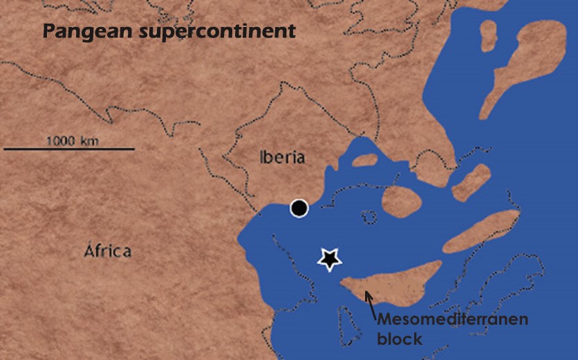 Figure 1. A palaeographic map of the eastern part of the Pangean supercontinent during the Triassic which shows the position of Iberia and the Meso Mediterranean block. The approximate position where deposited sediments that later formed the rocks of the Sierra de Orihuela and Callosa de Segura is indicated with a star. Blue identifies the areas covered by the Tethys Ocean. The circle indicates the position of the sediments which later formed the Triassic rocks that seem widely in the northern half of the province of Alicante.
Mainland Triassic to the South of Iberia.
During the Triassic the central part of Iberia was occupied by a chain of mountains crossed by large rivers that were gradually eroding them. As these rivers reached the flatter coastal plains and the multitude of small lagoons that characterized the coastline (Figure 2) they deposited the clay, silt and sandy deposits they had been carrying. In these small coastal lagoons evaporating sea water left behind a variety of salts, such as gypsum and halite, which were deposited in the bottom of the lagoons. Over time this process continued depositing greater depths of sediments until the formation of the rocks known as evaporites.
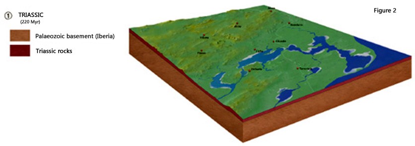
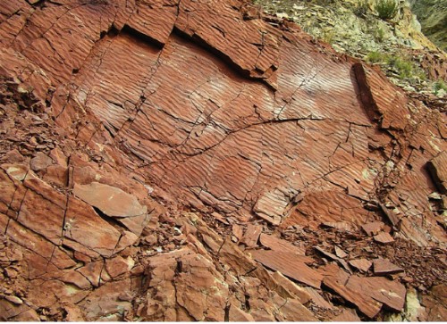
Fig 3. Magnificent outcrops of these Triassic materials, derived from sediment laid down in rivers and saline lakes, are found in Alicante province. These rocks are easily identifiable by their intense and varied colors and although reddish tones dominate, whitish bands and spots of salts, interspersed with green, black and orange are also common. These rocks are found in northern two-thirds of the province.
In the Tethys Sea close to the Meso Mediterranean block.
Another area in which the Triassic rocks of the province were formed was around the Meso Mediterranean block (Figure 4). An extensive shallow continental platform developed around this island in which carbonated sludges were deposited similar to those deposited in tropical seas today.
These sludges formed carbonate rocks, limestone and dolomite, with a very different appearance to those deposited in southern Iberia. These limestones and dolomites are currently found in the south of the province.
 Figure 4 is a transect representing the Tethys Ocean during the Triassic and shows the two areas where the Internal Zone rocks were deposited (Sierras of Callosa de Segura and Orihuela and Tabarca Island) shown in purple, and the External Zone rocks, shown in grey, widely represented in the northern half of the province. The green strata indicates the intrusion of subvolcanic rocks that failed to reach the surface, through faults in the basement rock. Forms dark green rocks called ophites that appear widely on the island of Tabarca and around Orihuela.
Iberia and the tethys ocean between 200 and 70 million years ago
This long period in the history of our planet, more than 100 million years, is only represented in the northern part of the province. For this reason we will focus on events that happened in the south of Iberia, leaving aside for the moment what was happening in the Meso Mediterranean block area.
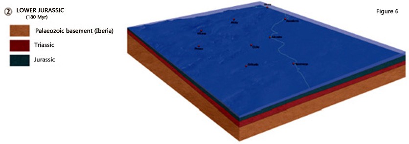
The Jurassic sea level rise (approximately 200 million years ago)
At the beginning of the Jurassic tectonic movements caused the Tethys basin to subside, this subsidence resulted in the flooding of land that had emerged in southern Iberia where Triassic rivers and coastal lagoons were located (Figure 6). An extensive marine bench formed onto which carbonate muds were deposited that, with the passage of time, transformed into limestone and dolomite .
Sometimes, when carbonate sludge is mixed with clay or sand from the continent, marly, loamy, sandy limestone or marls were formed. This process continued over many millions of years, from the Jurassic to the end of the Paleogene and resulted in an accumulation of several thousand meters of rock strata. These marine carbonate rocks constitute almost all of the Alicante mountains.
How were Alicante’s rocks formed?
The opening of the Atlantic Ocean and the Tethys Ocean
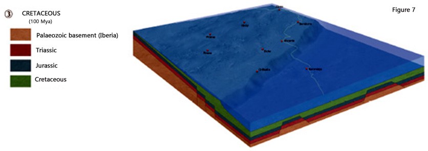
In the early Jurassic, some 180 million years ago, the Atlantic Ocean began to open up between the Eurasian and American continents. At the same time, the Tethys, which up until then had been a relatively small and shallow sea began to grow, becoming a real Ocean. This process caused the marine bench to the south of Iberia to fracture along fault lines causing a stepped relief of the seabed (Figure 7)
In this way, the marine bench was divided into two major sectors: the Pre-Betic, located in the vicinity of Iberia and closer to the coast with a shallow sea and the Sub-Betic, located to the south, away from the coast, in which pelagic marine sediments were deposited at greater depths.
Meanwhile, the Meso Mediterranean block remained stable, or at least part of it, raising areas that previously had been submerged. This emergence from the Tethys meant that sediments were not deposited from Jurassic to the Cretaceous.
 The formation of the betic mountain range (between 70 million years and today)
The approximation of Africa to the Meso Mediterranean block and Eurasia about 70 million years ago represented a significant change in movement of the Earth’s tectonic plates. Africa, which until then was separated from Eurasia, began to move northward and as a result the Tethys Ocean, that separated both continents, slowly began to close. The approach of Africa to Eurasia also caused the Meso Mediterranean continent, situated between the two, to be propelled laterally westward (Figure 8).
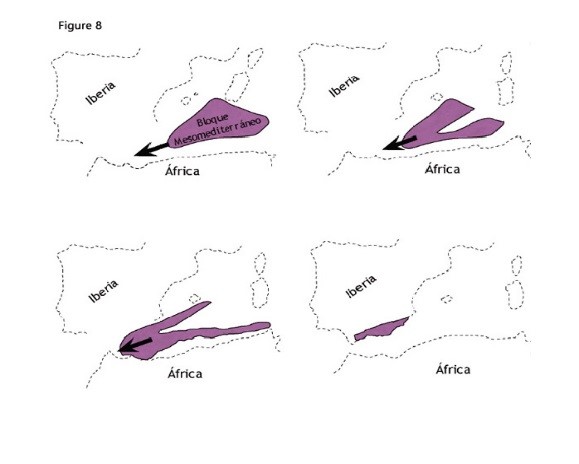
Figure 8 shows the evolution of the Meso-mediterranean block over the last 70 million years.
At some point during this process tectonic movements caused the rocks of the ocean floor to be drawn down and subducted beneath the continents. In subduction zones, sedimentary rocks are subjected to increased pressure and temperature causing their transformation via metamorphism, into metamorphic rock.
As the Meso Mediterranean bock moved westwards, the sediments of the coastal areas accumulated in one of these subduction zones. This transformed these sedimentary rocks into metamorphic rocks which can now be seen forming the Sierra de Orihuela and Callosa de Segura.
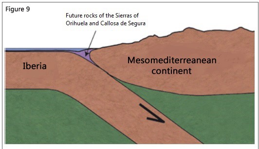
Figure 9. Schematic representation of the subduction of Iberia beneath the Meso-mediterranean continent about 50 million years ago. The diagram shows existing rocks of the Sierra de Orihuela and Callosa de Segura in purple, during the subduction they reached a depth of about 30 kilometres with pressures of up to 9 kilobars and temperatures of 360 ° C.
Marble or limestone and dolomites?
We know that the rocks of the sierra de Orihuela have experienced metamorphic conditions at some point in its geological history. Some research indicates that they reached approximately 360°C (metamorphism starts at 200°C) and 9 kilobars of pressure. These data reflect that the rocks we see today on the surface in the Sierra de Orihuela and Callosa were underground at a depth of more than 20 km.
Under normal geological conditions the carbonate rocks of the Sierra de Orihuela should have been transformed into marble, and would have a degree of recrystallization such as, for example, marble from Macael in Almería province of Carrara Italy. However, they had to have experienced very special conditions because these carbonate rocks still have a similar appearance to the sedimentary limestones and dolomites. Therefore, we are faced with a strange case in which carbonate rocks which have undergone metamorphic conditions but still maintain the original appearance of the sedimentary rocks.
The collision of the Meso Mediterranean block and Iberia
The Meso Mediterranean continent continues to move westward until, 19-20 million years ago, it collides with Iberia. The rocks in the collision zone were heavily distorted, folding and breaking (Figure 10) until the tectonic pressure forced these rocks to rise and emerge from the Tethys Ocean, gradually forming the mountain range known as the Cordillera Betica, or the Betic Range, that traverses southern Spain.
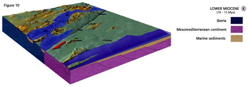
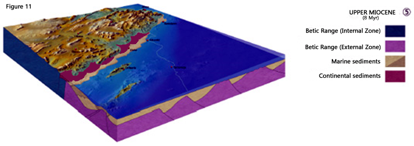
The displacement of the Meso Mediterranean continent continued up to around 8 million years ago, when it finally stopped the rocks of the External Zone became permanently welded to the south of Iberia (Figures 8 & 11). This fragment of the Meso Mediterranean continent attached onto mainland Iberia is currently referred to as Internal Zone of the Cordillera Betica (Figure 8) and its rocks constitute, amongst others, the sierras Nevada, Filabres, Gador, Lújar, Tejeda and Almenara, as well as the mountains of Callosa de Segura, Orihuela and the island of Tabarca. Whilst this was occurring in southern Iberia the African plate continued to move northward and slowly closed the Tethys Ocean to form the Mediterranean Sea.
The last 8 million years
As mentioned above, approximately 8 million years ago, during the late Miocene, two new changes in the movement of the tectonic plates had important consequences for the relief of the south of the Iberian Peninsula in general and Alicante province in particular. On the one hand the Meso-Mediterranean continent stops its shift toward the west. (Figure 8). On the other hand, the African plate, which had gradually been moving northwards, begins to collide with the Eurasian plate. The geology of Alicante continues to evolve, this process continues today with both plates still approaching at a speed of about 5 mm/year.
Throughout the region, the collision of these plates produces forces that generate large scale folding and faulting. Some of these folds can be seen in the Sierra de Crevillent, the Pantano de Elche and Santa Pola, La Marina and Guardamar. These folds, despite being softer than those produced in previous stages, are largely responsible for the current relief in Alicante province, especially in its southern half.
However, although Iberia and the Meso Mediterranean continent were now attached, the coastline still had not acquired its present shape as much of the Meso Mediterranean plate was still beneath the Mediterranean Sea. When the Meso Mediterranean finally came to rest it was effectively wedged between the static Eurasian plate and northward moving African plate until, about 6 million years ago, started the most significant event in the young Mediterranean’s history.
The Messinian Salinity Crisis
The name sounds like some sort of Suez Crisis, but actually comes from the late 19th century when scientists started noticing outcrops of thick deposits of salt in places like Messina in Sicily, northeast Libya, Italy, and southern Spain and from these observations the salinity crisis theory started to be developed. It was in 1867 that the Swiss geologist Karl Mayer-Eymar named the period of these thick accumulations of salt the Messinian and in 1967 Ruggieri suggested these deposits were from the late Miocene and coined the term “Messinian Salinity Crisis”.
These thick accumulations of salt, in places more than 1000 meters deep, suggested that the entrance of seawater from the Atlantic had been interrupted causing the Mediterranean Sea to dry out and the seawater salts to be deposited as evaporites. This idea was given a strong boost by the discovery of many submerged canyons that were cut into the flanks of the dry Mediterranean basin by rivers, like the River Nile, flowing into the abyssal plain. This salinity crisis appears to have lasted for some 700,000 years, the thick deposits suggesting repeated flooding and desiccation rather than a one-off event.
[popup_trigger id=”2317″ tag=”span”]What caused the Messinian Salinity Crisis?[/popup_trigger]
Finally, 5.3 million years ago the Messinian Salinity Crisis concluded with the Atlantic Ocean breaching the land barrier at the Strait of Gibraltar. This is thought to have been a result of tectonic subsidence, the resulting floodwaters, known as the Zanclean Flood, flowed in at a rate of 300 km per hour creating a 250 meter deep by 200km long incision that eroded some 40 cm of rock every day at its peak equivalent to ten times the discharge of the Amazon River. It is thought that the basin almost completely refilled within a few years and reached global sea levels within a few centuries – a truly catastrophic event after which the current outline of the Iberian Peninsula finally took shape.
 The main exception to this was Alicante where the most easterly part of the Betic chain formed a narrow peninsula connecting the mainland with the Balearic Islands, a fact that is reflected in the similar geology and flora of Alicante and the Balearics.
Pleistocene sea level fluctuations.
During the Pleistocene (2.6 and 0.01 million years ago) the succession of alternating cold glacial and warm interglacial periods caused important sea level fluctuations as the volume of water stored as ice in the polar ice caps varied. The marine terraces that record the events of high interglacial sea levels on Alicante’s coastline are mainly from the upper Pleistocene. In some cases, as in the Anticline of La Marina, recent tectonic activity has favored the elevation and preservation of older Pleistocene terraces.
The last rise in sea level, known as the Flandrian transgression, was particularly significant in the formation of Alicante’s relief. About 18,000 years ago, during the last glacial episode, sea level was between 100 and 150 m below its current position. The melting of the polar icecaps produced a rapid rise in global sea levels until 6,000 years ago when they reached present day levels. It was at this time that the sea invaded the ancient Segura River Valley of creating a small Gulf in which marine waters penetrated several kilometers’ westwards. Subsequently this gulf was cut off from the sea by a sand bank which created a very shallow coastal lagoon that covered a wide area of the Vega Baja del Segura. This process has progressed, by both natural causes and human actions until the original lagoon has been reduced to two small wetlands: The Hondo lagoon and the Salinas de Santa Pola.
The geology of Alicante.
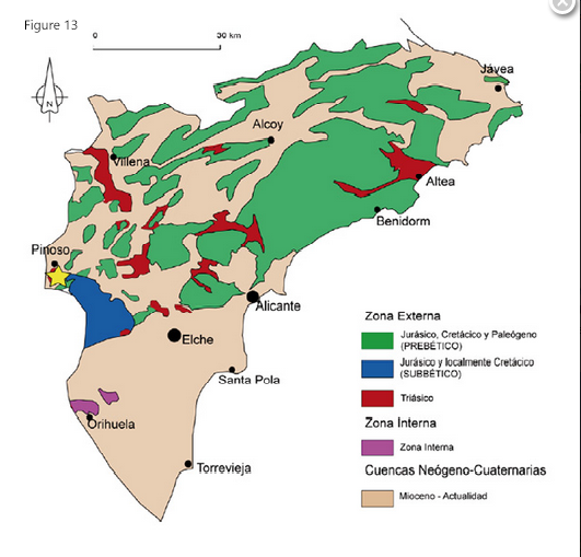
Figure 13 shows the current distribution of rock types in Alicante Province.
The geology of Alicante has evolved as tectonic forces and geological changes over the last 200 million years have produced the complex pattern we see today. Within relatively short distances on the ground we can cover hundreds of millions of years of Earth history.
Acknowledgments:
Geology of Alicante Province.
Much of this article and the diagrams used is based on and translated from the book Senderos Geólogicos – Guia de Lugares de Interes de la Province de Alicante. Diputacion de Alicante.
http://www.senderosdealicante.com/geologicos/
Crisis salina del Messiniense in Wikipedia:
http://es.wikipedia.org/wiki/Crisis_salina_del_Messiniense
Messinian salinity crisis regulated by competing tectonics and erosion at the Gibraltar arc. D. Garcia-Castellanos & A. Villaseñor
http://www.nature.com/nature/journal/v480/n7377/full/nature10651.html
The Zanclean Flood: Refilling the Mediterranean, 13 July 2012 by kuschk
http://basementgeographer.com/the-zanclean-flood-refilling-the-mediterranean/
« Walking holidays on the Costa Blanca